These days forecasting the wind and weather has become an integral part of the spearfisherman’s day to day life. The need to have your finger on the ‘pulse’ so to speak and be ready for when all the right conditions line up is essential to successfully planning any dive trip.
Back in the day, there were dodgy radio ski boat forecasts, synoptic charts, and a barometer. I can remember getting faxed copies of the synoptic chart and having to try work out what the next few days would bring and then watching the barometer to time the different changes in the weather.
These days things are much easier! 7 day forecasts on the internet can accurately, often down to the hour, predict what the weather is going to do. There are however still some basic skills needed to read these forecasts and to apply them with your local knowledge of the area to work out when the conditions will be ideal.
In this article, we are going to go over just two of the most popular wind and swell forecasting sites, Windguru.com and Windfinder.com. Both sites have their merits and you will need to use both to find out which suits your location best. I personally prefer Windfinder, as I find it to be the most accurate in the Durban area. This is because Windfinder uses the Met offices at major airports and King Shaka International is only 20km from my home. This means that the info is updated every hour giving very accurate forecasts and a ‘real-time’ wind graph.
Windguru, on the other hand, has a handy feature that allows you to ‘Spot Search’ and find remote locations. Windguru uses predictive tools from Met offices around the world to create virtual weather stations and forecasts. This is pretty handy for remote spots in Mozambique and the west coast.
The best thing to do is load both pages for the forecasts in your area and watch them over a 2 to 3 week period. You will soon learn which one is the most accurate. Sometimes the forecasts show the winds as generally stronger or weaker than they are. For example I know that Windfinder in Durban generally shows the wind slightly lighter than it will actually blow. So, I use the forecast as a best case scenario, so when I see the forecast showing some wind I know it’s going to blow hard.
On the other hand, the St Lucia forecast is the opposite and shows the worst case scenario. When it shows that there is no wind, you can be assured that it’s going to be dead calm.
Other forecasts that are good to look at are Buoyweather.com and Magicseaweed.com, these use the same info but are more geared towards swell and surf. I often cross reference different sites to get a better overall picture.
LEGEND DESCRIPTIONS:
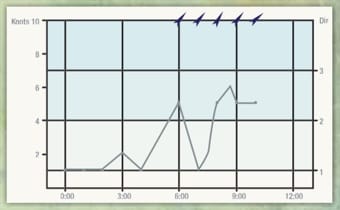
Wind direction: This the direction of the wind indicated by an arrow showing which way the wind is blowing to. Also see the Wind Table.
Wind speed: This is the average expected speed in knots, you can change this to km/h.
Wind gusts: This is the expected maximum wind gusts.
Wave direction: Swell direction using an arrow in the direction the swell is travelling. i.e. An arrow pointing straight up the page is a south swell. Wave height: This indicates open ocean swell height and you will need to work out what this translates to for each spot.
Wave heriod: This indicates the distance between swells. Generally the longer (bigger) the period or distance the stronger the swell. Cloud cover / Precipitation: This is the section the wives look at… Sunshine and no rain unfortunately do not mean good diving weather or sea conditions!
Air pressure: This is indicated in hectopascals (hPa) and predicts the air pressure. This is important as you will soon be able to gauge the severity of a storm by looking at the air pressure. Some divers swear that the fish will be ‘on’ when the pressure is falling.
Air temperature: Another section the wives look at; but that is of no use when spearing.
WINDFINDER REAL TIME
WINDFINDER

WINDGURU